One goal of our work is a full 24-hour simulation of all of Switzerland, including transit traffic, freight traffic, and all modes of transportation. The simulation should include within-day replanning, making it capable of evaluating ITS devices/strategies. This will involve about 7.5 million travelers, and more than 20 million trips (including short pedestrian trips, etc.).
Our implementation has not yet reached this goal, and it will take some more time until we get there. However, in order to make sure that our system will be useful in the real world, systematic studies are performed with intermediate levels of system capabilities. At this point, there is unfortunately no ITS capability that can be tested. Nevertheless, our results allow to make some predictions about the possible usefulness of our system.
In the following, results of a study done in 2002/03 are reported. Further details of this study can be found in Raney et al. (46).
That study took a subset of the data for the full 24-hour, car-only simulation, and used the demand for the morning rush-hour, from 6:00 AM to 9:00 AM. This subset contained about 1 million trips.
The input data consisted of two parts: the street network, and the demand.
The street network was originally developed for the Swiss regional planning authority (Bundesamt für Raumentwicklung), and covered Switzerland. It was extended with the major European transit corridors for a railway-related study (56). The network supposedly contained the status for 1999, but contained at least one major error (a high capacity tunnel in Zürich was missing). Our initial simulations resulted in traffic gridlock in Zürich, which was also reflected in the VISUM (45) assignment displaying V/C ratios significantly above 100%. A manual comparison with a higher resolution network of Zürich led to the conclusion that capacity in Zürich was in general significantly underestimated; in consequence, we manually increased the corresponding road capacity for transit corridors through Zürich in our network. We can only speculate what led to these network errors.
After our modifications, the network has the fairly typical size of 10564 nodes and 28622 links. Also fairly typical, the major attributes on these links are type, length, speed, and capacity.
Our starting point for demand generation for the scenario described here were 24-hour origin-destination matrices from the Swiss regional planning authority (Bundesamt für Raumentwicklung).
The original 24-hour matrix was converted into 24 one-hour matrices using a three step heuristic (55). The first step employed departure time probabilities by population size of origin zone, population size of destination zone and network distance. These were calculated using the 1994 Swiss National Travel Survey (9). The resulting 24 initial matrices were then corrected (calibrated) against available hourly counts using the OD-matrix estimation module of VISUM. Hourly counts are available from the counting stations on the national motorway system. Finally, the hourly matrices were rescaled so that the totals over 24 hours match the original 24h matrix.
VISUM assignment of the matrices showed that the patterns of congestion over time are realistic and consistent with the known patterns. The Zürich congestion problem, mentioned above, is contained in the assignment, but did not show up at this higher level view.
For the multi-agent simulation, these hourly matrices were then disaggregated into individual trips. That is, we generated individual trips such that summing up the trips would again result in the given OD matrix. The starting time for each trip was randomly selected between the starting and the ending time of the validity of the OD matrix.
The OD matrices assumed traffic analysis zones (TAZs) while in our simulations trips start on links. We converted traffic analysis zones to links by the following heuristic:
This led to a list of approximately 5 million trips, or about 1 million trips between 6:00 AM and 9:00 AM. Since the origin-destination matrices are given on an hourly basis, these trips reflect the daily dynamics. Intra-zonal trips are not included in those matrices, as by tradition.
The above scenario was fed into two different models: First, into a VISUM (PTV, www.ptv.de) assignment which is a relatively standard assignment (52) except that it is dynamic on an hourly basis (55,24), and second into an agent-based approach. The components of the agent-based approach were as follows:
Figure 3 shows a result of the Switzerland 6-9 Scenario. As one would expect, there is more traffic near the cities than in the country. Jams are nearly exclusively found in or near Zürich (near the top; see close-up). As of now, it is unclear if this is a consequence of a higher imbalance between supply and demand than in other Swiss cities, or a consequence of a special sensitivity of the queue simulation to large congested networks.
![\includegraphics[height=0.42\textwidth]{50_snap0800fixed-fig.eps}](img34.png)
![\includegraphics[height=0.4\textwidth,bb=260 160 360 300,clip=true]{50_snap0800fixed-fig.eps}](img35.png)
|
|
[] ![\includegraphics[width=0.49\hsize]{flow_vs_count_78only-gpl.eps}](img36.png) [] []![\includegraphics[width=0.49\hsize]{assignment_vs_counts-gpl.eps}](img37.png) |
Figure 4 shows a comparison between the simulation output of Fig. 3 and field data taken at counting stations throughout Switzerland (see Sec. 5.2 and 10). The dotted lines, drawn above and below the central diagonal line, outline a region where the simulation data falls within 50% and 200% of the field data. We consider this an acceptable region at this stage since results from traditional assignment models that we are aware of are no better than this (Fig. 4(b); see also 22).
Figure 4(b) shows a comparison between the
traffic volumes obtained by IVT using VISUM assignment against the
same field data.
Visually one would conclude that the simulation results are at least
as good as the VISUM assignment results.
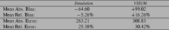
Table 1 confirms this quantitatively.
Mean absolute bias is
![]() , mean absolute error
is
, mean absolute error
is
![]() , mean relative bias is
, mean relative bias is
![]() , mean relative error is
, mean relative error is
![]() , where
, where
![]() means that the values are
averaged over all links where field results are available.
means that the values are
averaged over all links where field results are available.
The mean relative bias numbers mean that the MASim underestimates flows by about 5%, whereas the VISUM assignment overestimates them by 16%. The mean relative error between the field measurement and the MASim is 25%, between the VISUM assignment and reality 30%. These numbers state that the MASim result is better than the VISUM assignment result. Also, the MASim results are better than what we obtained with a recent (somewhat similar) MASim study in Portland/Oregon (22); conversely, the assignment values in Portland were better than the ones obtained here.
What makes our result even stronger is the following aspect: The original OD matrices were actually modified by a VISUM module to make the assignment result match the counts data as well as possible. These modified OD matrices were then fed into the MASim, without further adaptation. It is surprising that even under these conditions, which seem advantageous for the VISUM assignment, the MASim generates a smaller mean error.
As stated before, the above study did not contain aspects of ITS. Nevertheless, they allow some outlook towards future possibilities. First, the above study makes clear that it is possible to use MASim for large scenarios: Switzerland, with about 7 million inhabitants, is a good proxy for a large metropolitan area. Second, the quality of the results is, at this stage of the technology development, about as good as that of assignment methods. Further improvements are expected with further uses of the MASim technology. Overall, this indicates the general applicability of MASim for transport planning. Since ITS is conceptually much easier to integrate into MASim than into assignment, it is expected that real-world applications of ITS in MASim will soon become available and useful.